


Voting Districts not defined, Atlantic County, New Jersey
About
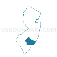
Outline

Summary
| Unique Area Identifier | 616547 |
| Name | Voting Districts not defined |
| County | Atlantic County |
| State | New Jersey |
| Area (square miles) | 54.69 |
| Land Area (square miles) | 0.00 |
| Water Area (square miles) | 54.69 |
| % of Land Area | 0.00 |
| % of Water Area | 100.00 |
| Latitude of the Internal Point | 39.37723490 |
| Longtitude of the Internal Point | -74.36244820 |
Maps


Graphs
Select a template below for downloading or customizing gragh for Voting Districts not defined, Atlantic County, New Jersey


Neighbors
Neighoring Voting District (by Name) Neighboring Voting District on the Map
- Atlantic City city ward 1 voting district 2, Atlantic County, NJ
- Atlantic City city ward 1 voting district 3, Atlantic County, NJ
- Atlantic City city ward 2 voting district 1, Atlantic County, NJ
- Atlantic City city ward 3 voting district 2, Atlantic County, NJ
- Atlantic City city ward 4 voting district 1, Atlantic County, NJ
- Atlantic City city ward 5 voting district 1, Atlantic County, NJ
- Atlantic City city ward 5 voting district 2, Atlantic County, NJ
- Atlantic City city ward 5 voting district 4, Atlantic County, NJ
- Atlantic City city ward 6 voting district 1, Atlantic County, NJ
- Atlantic City city ward 6 voting district 3, Atlantic County, NJ
- Atlantic City city ward 6 voting district 4, Atlantic County, NJ
- Brigantine city ward 1 voting district 1, Atlantic County, NJ
- Brigantine city ward 2 voting district 1, Atlantic County, NJ
- Brigantine city ward 3 voting district 1, Atlantic County, NJ
- Brigantine city ward 4 voting district 1, Atlantic County, NJ
- Galloway township voting district 8, Atlantic County, NJ
- Longport borough voting district 1, Atlantic County, NJ
- Margate City city voting district 1, Atlantic County, NJ
- Margate City city voting district 11, Atlantic County, NJ
- Margate City city voting district 2, Atlantic County, NJ
- Margate City city voting district 3, Atlantic County, NJ
- Margate City city voting district 4, Atlantic County, NJ
- Margate City city voting district 7, Atlantic County, NJ
- Margate City city voting district 8, Atlantic County, NJ
- Margate City city voting district 9, Atlantic County, NJ
- Ventnor City city voting district 1, Atlantic County, NJ
- Ventnor City city voting district 2, Atlantic County, NJ
- Ventnor City city voting district 3, Atlantic County, NJ
- Ventnor City city voting district 7, Atlantic County, NJ
- Ventnor City city voting district 8, Atlantic County, NJ
- Voting Districts Not Defined, Cape May County, NJ
- Voting Districts not defined, Ocean County, NJ
Top 10 Neighboring County Subdivision (by Population) Neighboring County Subdivision on the Map
- Atlantic City city, Atlantic County, NJ (39,558)
- Galloway township, Atlantic County, NJ (37,349)
- Ventnor City city, Atlantic County, NJ (10,650)
- Brigantine city, Atlantic County, NJ (9,450)
- Margate City city, Atlantic County, NJ (6,354)
- Longport borough, Atlantic County, NJ (895)
- County subdivisions not defined, Atlantic County, NJ (0)
- County subdivisions not defined, Cape May County, NJ (0)
- County subdivisions not defined, Ocean County, NJ (0)
Top 10 Neighboring Place (by Population) Neighboring Place on the Map
- Atlantic City city, NJ (39,558)
- Ventnor City city, NJ (10,650)
- Brigantine city, NJ (9,450)
- Margate City city, NJ (6,354)
- Longport borough, NJ (895)
Top 10 Neighboring Elementary School District (by Population) Neighboring Elementary School District on the Map
- Galloway Township School District, NJ (37,349)
- Ventnor City City School District, NJ (10,650)
- Brigantine City School District, NJ (9,450)
- Margate City School District, NJ (6,354)
Top 10 Neighboring Secondary School District (by Population) Neighboring Secondary School District on the Map
Top 10 Neighboring Unified School District (by Population) Neighboring Unified School District on the Map
- Atlantic City School District, NJ (39,558)
- Longport Borough School District, NJ (895)
- School District Not Defined (Water), NJ (0)
Top 10 Neighboring State Legislative District Lower Chamber (by Population) Neighboring State Legislative District Lower Chamber on the Map
Top 10 Neighboring State Legislative District Upper Chamber (by Population) Neighboring State Legislative District Upper Chamber on the Map
Top 10 Neighboring 111th Congressional District (by Population) Neighboring 111th Congressional District on the Map
Top 10 Neighboring Census Tract (by Population) Neighboring Census Tract on the Map
- Census Tract 105.01, Atlantic County, NJ (7,299)
- Census Tract 25, Atlantic County, NJ (4,030)
- Census Tract 130, Atlantic County, NJ (3,616)
- Census Tract 101.01, Atlantic County, NJ (3,497)
- Census Tract 2, Atlantic County, NJ (3,202)
- Census Tract 23, Atlantic County, NJ (2,861)
- Census Tract 101.05, Atlantic County, NJ (2,760)
- Census Tract 24, Atlantic County, NJ (2,752)
- Census Tract 133.02, Atlantic County, NJ (2,727)
- Census Tract 135, Atlantic County, NJ (2,678)